What Google Autocomplete tells us about countries

Together with my collaborators in the “Information Geographies” project at the Oxford Internet Institute, I have published a blogpost that analyses Google Autocomplete. This is seemingly a popular pastime these days, but unlike the maps I have seen so far, we don’t just map the most prominent term for each country but actually visualise multiple categories, often in one map.

Why does it matter?

Autocomplete is Google’s ‘type-ahead’ suggestion algorithm: As soon as you enter a word or two into the Google Search field, the algorithm will try to guess the completion of your query and offers you a list of likely queries. This functionality is baked into Google’s interface and cannot be turned off by the user.

It’s unclear if and how much such algorithms affect our perception of the subjects that we are querying for. But we can certainly say that they reduce serendipity and can help reinforcing filter bubbles.
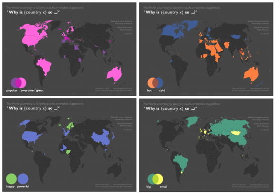
 

Google-Autocomplete-countries-Oxford-Internet-Institute-Ralph-Straumann


Data acquisition and cartographic technique

The data that went into these maps Continue reading “What Google Autocomplete tells us about countries”

OpenStreetMap: A valid competitor to official base maps?

Still in last year, Cédric Moullet, amongst others MapFish and GeoExt contributor, sparked a discussion by his post “Why OpenStreetMap fails to replace official or proprietary base maps in a sustainable way ?” (note how this doesn’t sound like a question but bears a question mark ;) For simplicity, I will re-list Cédric’s 13 points here: … Continue reading OpenStreetMap: A valid competitor to official base maps?

Address Is Approximate

A sweet piece of art, wonderfully executed (and using Street View) – enjoy it in full screen:   (Head over to Vimeo, if the embedded version doesn’t work for you. It often doesn’t for me.) The film was made by Tom Jenkins at The Theory film production company. (found via FlowingData) Continue reading Address Is Approximate

When mapping is political

Maps chart territory and can thus be used and abused, for example, to convey one’s own interpretation of a territorial dispute. In such cases maps exhibit their considerable potential to invoke political disputes. With the advent of online mapping and the gripe very few large companies have on it (think Google, Microsoft, Yahoo and very few … Continue reading When mapping is political

“What was there” project: More geocoded old photographs

While the news on Historypin is still fresh, the next project made its way onto my radar. Like Historypin, the “What was there” project crowdsources photos from times past and has them geocoded by users/contributors a.k.a. produsers. You can browse the collection on their website or using their mobile app – provided you’re living in … Continue reading “What was there” project: More geocoded old photographs

Some GEarth tips

While Google Earth is still around, it makes sense to maximise its usefulness. The Google Earth Blog shares some nice pointers how to tune your GEarth installation in case you experience performance issues. They’ve also recently covered a company called KMZmaps.com which offers a set of custom KMZ overlays for use in GEarth. Honestly, I … Continue reading Some GEarth tips

Timelapse video lets you ride the ISS – Canada to Chile in a minute

Behold this HD timelapse video of the view aboard the International Space Station (ISS). I can’t find first-hand information on its author, but PopSci claims that it was created by a certain James Drake, who stitched together 600 publicly available images shot from the ISS. The cities’ lights look great, especially together with the frequent thunderstorms lighting up the clouds (watch in HD and full-screen)! Continue reading “Timelapse video lets you ride the ISS – Canada to Chile in a minute”

A GEarth challenger from Iran

Apparently, Iranian officials have decided to build a service to counter the success of Google Earth, which is described as a website that “was designed and built by the global arrogance for espionage purposes and to gather information from other countries” (Brigadier-General Mohammad Hasan Nami quoted in a Mehr news agency report). The new website … Continue reading A GEarth challenger from Iran

Motivating volunteers

Crowdsourcing projects like OpenStreetMap, Google Map Maker or Building Maker without compensation for contributors rely on volunteers’ efforts. There are various studies which try to shed light on the motivational factors of such volunteers. One way to motivate people to contribute their time and effort can be to make them feel that they are part of … Continue reading Motivating volunteers

Google in Libya

Maps are about territory. And in history, cartography has often been (ab)used to political ends. Due to its big popularity and global visibility Google’s geo-products have attracted their share of border and naming debates and disputes over time and the change of a border’s status or the name of a proportion of land in, for … Continue reading Google in Libya