Living in Switzerland you don’t get to experience many weather phenomena as dramatic as hurricanes and tornados. However, a former colleague of mine investigates the movement patterns of hurricanes to find similarities between individual storms. And in 2004, I was professionally dealing with hurricane Ivan. Ivan was a Category 5 hurricane and is, apparently, the 10th most intense Atlantic hurricane ever recorded. Back then we ordered a Quickbird image (and were lucky enough to get one without too much cloud coverage) and did both a qualitative and quantitative damage assessment of Grand Cayman Island.
These have so far been my only exposures to the study of extreme weather events and, specifically, to the analysis of storm-induced damage captured by means of remote sensing. But some days ago NASA’s Earth Observatory has released a stunning image of a tornado track (of one of the several tornados which have struck Massachusetts in early June 2011) that is well visible from space. Head past the break for the image and more info.
Snip from Earth Observatory:
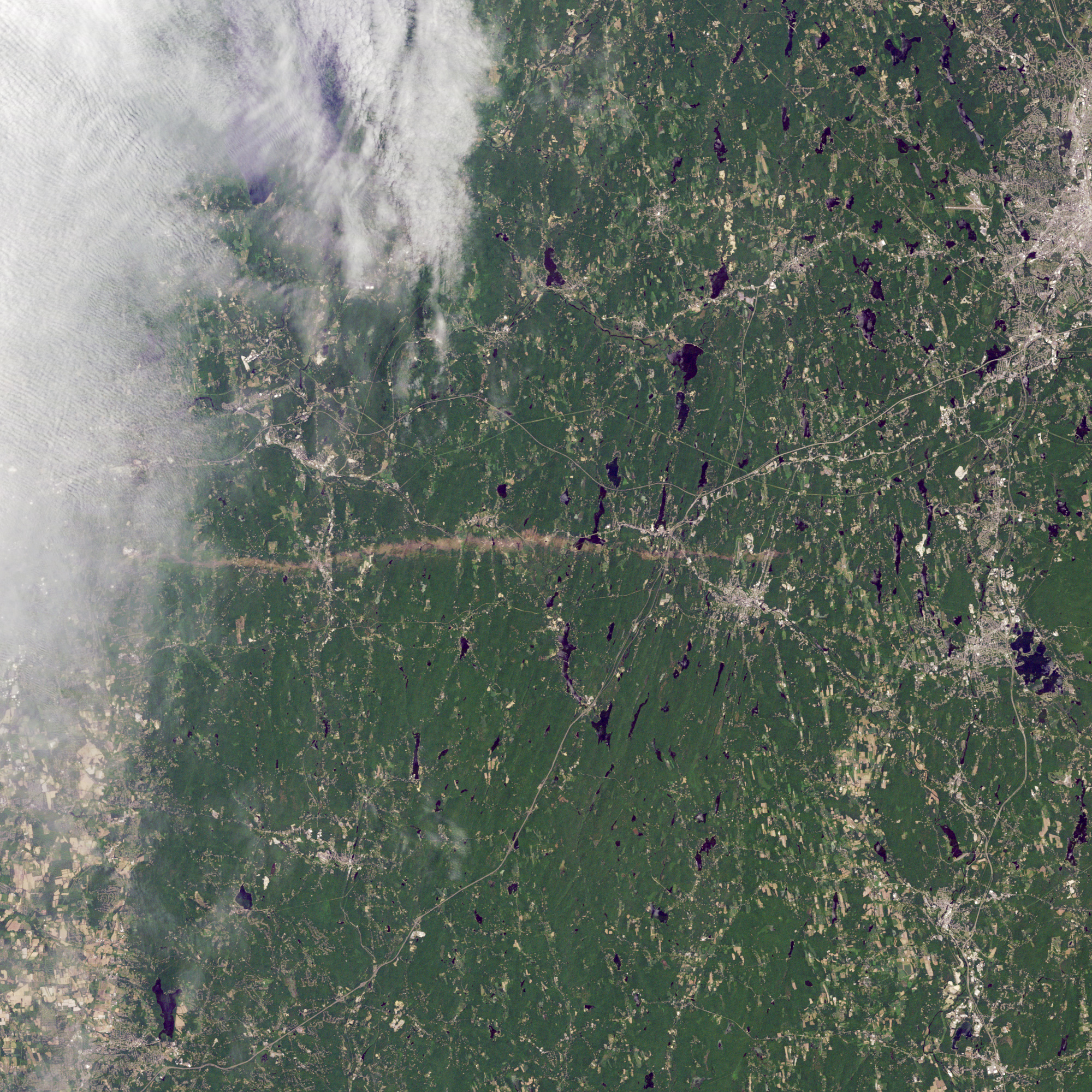
On June 1, 2011, a supercell thunderstorm developed over western Massachusetts. The storm produced an EF3 tornado that cut a 39-mile (63-kilometer) track of destruction across southwest and south-central Massachusetts. (…) According to The Boston Globe, Massachusetts state police reported a tornado on the ground and cars overturned near Interstate 84 in Sturbridge at 5:22 p.m. on June 1.
One of NASA’s flagship sensors, Thematic Mapper on board the Landsat 5 satellite launched in 1984 (!) captured from about 705 kilometres above the earth’s surface below natural-color image at 30 metres resolution on 5th of June 2011, four days after the passage of the tornado.

You can clearly see the path of destruction and barren land caused by the tornado contrasting with green vegetation around it. In some places you can also get a feeling how strongly human-made structures like settlements have been affected. At its widest, the tornado path spans about 0.8 kilometres. NASA also features a before/after comparison.
Earlier this year, meteorologist’s at NASA’s Marshall Space Flight Center have studied tornados in Alabama using data from another multispectral sensor, ASTER, onboard Terra. Using the visible and near-infrared bands of ASTER, analysts are capable of picking up the path of destruction by a tornado from remotely sensed imagery:
A demolished house, debris and soil scattered on vegetated surfaces, and damaged trees and crops all change the pattern of reflected radiation measured by the satellite. We can analyze these patterns to help storm survey teams evaluate the damage.
An example of such analysis can be glimpsed from below image, combining two bands in the visible parts of the electromagnetic spectrum and one band in the near-infrared part to show vegetation in magenta and absence of vegetation in cyan.

Thus, remote sensing can be an invaluable tool in the relatively reliable and quick assessment of tornado (and hurricane) damage for example in areas which are difficult or impossible to reach by ground teams or in remote areas where tornado damages may go unreported and where ground teams don’t expect tornado touchdowns to have happened.
If this brief description struck your interest: Large image of the tornado track in Massachusetts are available here, along with KML file for viewing in Google Earth and GeoTiff for your GIS. Brief and general description of remote sensing analysis of tornado tracks is available here along with an image of three parallel tornado tracks. (all sources courtesy NASA). Material for further reading on tornado image analysis is available here.
(via EarthSky)