Twitter networks – Mechanics

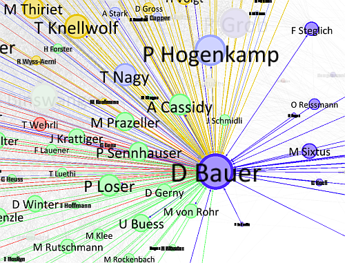
[Deutsch weiter unten] Recently, I’ve been working on a Twitter-related project with two friends of mine. As there’s nothing to present yet, I won’t go into detail regarding that project. But working on Twitter-related stuff led me to explore the generation, modelling, analysis and visualization of Twitter networks. Then, some weeks back, Swiss journalist/author/blogger David … Continue reading Twitter networks – Mechanics

Economist’s Africa Twitter map provides some teachable insights

Mark Graham has posted a critique of a “Twitter map” that featured in the Economist at Zerogeography. The map was compiled by Portland Communications and Tweetminster and shows the number of tweets per country (original version of the map can be found in this presentation by Portland Communications): Mark Graham raises these interesting points regarding … Continue reading Economist’s Africa Twitter map provides some teachable insights

OpenStreetMap: A valid competitor to official base maps?

Still in last year, Cédric Moullet, amongst others MapFish and GeoExt contributor, sparked a discussion by his post “Why OpenStreetMap fails to replace official or proprietary base maps in a sustainable way ?” (note how this doesn’t sound like a question but bears a question mark ;) For simplicity, I will re-list Cédric’s 13 points here: … Continue reading OpenStreetMap: A valid competitor to official base maps?

All the edits, deletions and insertions of Wikipedia in real time? – Voilà!

Wikistream shows you the sometimes immense activity that is going on backstage at Wikipedia. If the overall stream gets too fast to grasp anything (yes, that’s rather commonly the case!), you can filter what is shown to you by country and type of event. Pressing “P” pauses the stream of events. In these days where … Continue reading All the edits, deletions and insertions of Wikipedia in real time? – Voilà!

“What was there” project: More geocoded old photographs

While the news on Historypin is still fresh, the next project made its way onto my radar. Like Historypin, the “What was there” project crowdsources photos from times past and has them geocoded by users/contributors a.k.a. produsers. You can browse the collection on their website or using their mobile app – provided you’re living in … Continue reading “What was there” project: More geocoded old photographs

Motivating volunteers

Crowdsourcing projects like OpenStreetMap, Google Map Maker or Building Maker without compensation for contributors rely on volunteers’ efforts. There are various studies which try to shed light on the motivational factors of such volunteers. One way to motivate people to contribute their time and effort can be to make them feel that they are part of … Continue reading Motivating volunteers

Google in Libya

Maps are about territory. And in history, cartography has often been (ab)used to political ends. Due to its big popularity and global visibility Google’s geo-products have attracted their share of border and naming debates and disputes over time and the change of a border’s status or the name of a proportion of land in, for … Continue reading Google in Libya

OSM’s new license arrives…

… in my inbox today: Hi, Thank you for being a long-time contributor to the OpenStreetMap project. We are writing to ask you to login into your account at http://openstreetmap.org/user/terms and accept a new set of contributor terms. Why are we asking this? We need to ask you to explicitly grant permission for us to continue using … Continue reading OSM’s new license arrives…

GoopenStreetMaple: Information wants to be free

A rant just arrived in my inbox, by Mikel Maron via the Geowanking mailing list. While I think Mikel has some valid points, I am still (naïvely?) optimistic that the bleak picture he paints will not materialise in really bad outcomes. Hopefully.

But who knows. In two events (about one and about three years ago) I asked two GeoGooglers (Ed Parsons being one of them) about the relationship, and its anticipated development, between Google and OpenStreetMap (OSM). Unfortunately (but not surprisingly), the answers were very vague and suggested that OSM is “not perceived as a competition” by Google and also that cooperation is “not impossible”. Continue reading “GoopenStreetMaple: Information wants to be free”

Cartographic study of musical incest

A friend of mine discovered the Seattle Band Map (a.k.a. Cartographic Study of Musical Incest), a project by radio host Rachel Ratner, designer Keith Whiteman and computer scientist Golf Sinteppadon.

As Rachel Rutner describes in the project’s first blog post, she started the map as a nerdy personal project. The goal was to map out the bands she and her friends played in and which were interconnected by shared band members.
In the first draft (on paper) there were about 20 bands of the Seattle region:

Continue reading “Cartographic study of musical incest”