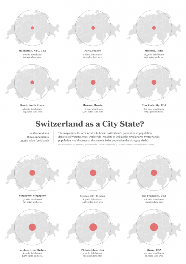
The Swiss population has grown more or less steadily over the last decades: With a current growth of about 1%, the Federal Statistics Office has forecast that Switzerland should have welcomed the 8 millionth inhabitant at some point this summer (jeez, I remember learning at school that Switzerland has 6.5 mio. inhabitants – you can … Continue reading Swiss population density versus that of cities
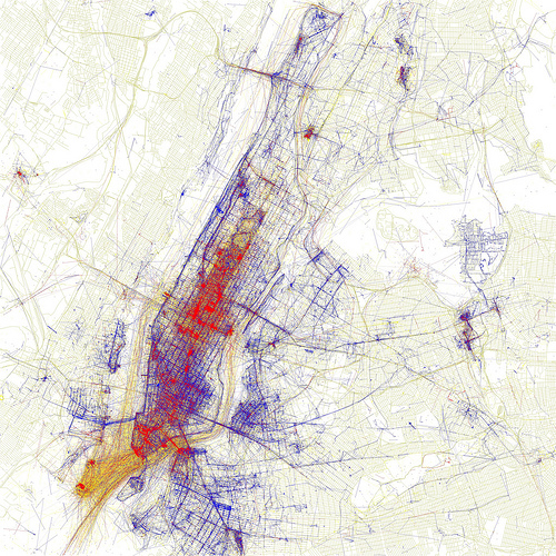
The Atlantic Cities has a nice portrait of Eric Fischer: Mapmaker, artist, or programmer?. If you have been following information visualization and geovisualization news online over the recent years, I bet you have come across Fischer’s work. A few examples: “Ultimately, almost everything I have been making tries to take the dim, distant glimpse of … Continue reading Eric Fischer: Mapmaker, artist and programmer
Another New York find: If the evolution of the NYC skyline and street grid interested you, you might also fall for this time-lapse movie by H. Caesar of his arrival in NYC by ship (click on “vimeo” in below player to watch the video at bigger size): A nice idea, to shoot time-lapse from a moving … Continue reading Time-lapse movie of shipping up to New York
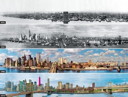
Interesting for history/urbanism/New York buffs: The evolution of the New York skyline and The evolution of the New York street grid (review of a book): The Commissioner’s Plan of 1811, the map and surveying scheme that set the blocks at 200 by 800 feet all the way up the length of the island, was an audacious … Continue reading Evolution of NYC
Hot from the press: Esri announces the acquisition of Procedural. The Switzerland-based company specialises in procedurally (i.e., rule-based) constructed 3D city models and is known, for example, for its reconstruction of ancient Rome. Procedural’s approach, embodied in its software CityEngine, allows for very fast modelling of urban scenes.
Esri’s move will considerably strengthen its stand in the 3D realm and maybe we will at some point see BIM (Building Information Modelling) by Esri? Spatial Sustain points out correctly that Esri hasn’t usually grown by acquisitions, but steadily by its own activities. Before that background, Esri’s move into 3D via Procedural seems rather outstanding and meaningful!
A Geography enthusiast at The Geography Collective (image by The Geography Collective)
The Urban Earth project by The Geography Collective aims at representing humanity’s habitat by walking across some of earth’s biggest urban areas. The motivation is critical of media and their portrayal of our living environments:
The media distorts the way we see our world(s) with stereotypical images highlighting the most extremes of places. Urban Earth aims to expose what our cities really look like away from the bias and spin of commercial agendas.
(This reminds me a bit of the distorted body image in the media and, for example, Dove’s Campaign for Real Beauty. For an ever-astounding short film [1:15 mins] click here. End of short side-track.)
The Rules
The recipe of Urban Earth is very simple: Walk across a city taking a photograph every 8 steps (roughly) and put them together sequentially into a movie. Photographs are always taken looking forward, without focusing on specific landmarks or ‘nice’ parts of the cityscape. The thing about an Urban Earth walk is that it tries to find normality within each city:
Geography is more important than many people think. A random route across a city may expose many things, but an Urban Earth walk is special because it attempts to reveal what a city is like for the people who live in it. Urban Earth is not about following the tourist trail or tracking down the most extreme places… it is about finding normality.