What Google Autocomplete tells us about countries

Together with my collaborators in the “Information Geographies” project at the Oxford Internet Institute, I have published a blogpost that analyses Google Autocomplete. This is seemingly a popular pastime these days, but unlike the maps I have seen so far, we don’t just map the most prominent term for each country but actually visualise multiple categories, often in one map.

Why does it matter?

Autocomplete is Google’s ‘type-ahead’ suggestion algorithm: As soon as you enter a word or two into the Google Search field, the algorithm will try to guess the completion of your query and offers you a list of likely queries. This functionality is baked into Google’s interface and cannot be turned off by the user.

It’s unclear if and how much such algorithms affect our perception of the subjects that we are querying for. But we can certainly say that they reduce serendipity and can help reinforcing filter bubbles.
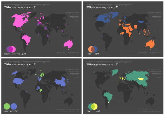
 

Google-Autocomplete-countries-Oxford-Internet-Institute-Ralph-Straumann


Data acquisition and cartographic technique

The data that went into these maps Continue reading “What Google Autocomplete tells us about countries”

Ubiquity of Python

I have written about the ubiquity of Python before and I’ve also given a talk in that direction at this year’s FOSSGIS conference (“Python as ‘glue’ in the GIS software domain: Sun glare analysis of road traffic accidents”). There is also a video of my talk here (but beware, it’s in German). So, this post by Tal … Continue reading Ubiquity of Python

Projection from WGS1984 to Swiss national grid (CH1903 LV03)

In my last project I used (standalone) Python for geoprocessing. Since ArcGIS or something like that was not there to help with projecting geodata from one coordinate system to another, I wrote a function which converts well-known WGS1984 to Swiss national grid coordinates (Swissgrid, CH1903 LV03). Swisstopo has the formulas of an approximate transformation and also funtions in C#, Javascript … Continue reading Projection from WGS1984 to Swiss national grid (CH1903 LV03)

Py all means

Over on his blog, Bill Dollins muses about the range and ubiquity of the Python language in the geospatial realm. It’s true – if you work with ESRI products on a daily basis (like I do) you almost can’t get away without using Python one way or the other, be it for scripting some workflow, … Continue reading Py all means